-
Our Government
-
- Board of Commissioners Meeting Calendar and Agendas County Calendar Departments Assessment & Tax Clerk/Elections County Administration District Attorney Emergency Management Fair Office Finance Human Resources Justice Court
- Departments Juvenile Department Parks Planning Public Health Public Transit - The Loop Public Works Sheriff's Office Surveyor Treasurer Veterans Services Boards and Commissions Airport Advisory Committee Board of Property Tax Appeals Budget Committee Compensation Board
- Boards and Commissions Equity Fund Committee Fair Board Forestland Classification Committee Parks Committee Planning Commission Road Committee Solid Waste Advisory Committee The Loop Advisory Committee Wolf Depredation Advisory Committee Enterprise Zones Enterprise Zones
-
- Roads & Land
-
Public Safety
-
- Sheriff's Office Sheriff John A Bowles Undersheriff Brian L Snyder Concealed Handgun Licenses Appointments Emergency Management Training Emergency Notifications Everbridge Contact Us!
- Sheriff's Department Divisions Communication Division Communications Center (911) Jail/Prisoners Administration Division Civil Unit Records Corrections Division Parole and Probation Community Service Work
- Operations Division Uniformed Patrol Criminal Investigations School Resource Officer Search and Rescue Court Security Marine Patrol Reserve Deputy OHV Park Justice Court Juvenile Department
-
- Health & Family
-
I Want To...
-
- Apply for a Job Alerts and Notifications Email Subscriptions Events and Meetings Agendas and Minutes Calendar Services Directory
- Contact the County Submit a Request or Concern County Offices Staff Directory County Ordinances Documents and Forms Documents and Reports Forms and Applications Budget Documents
- In the News County News Ride a Bus Find out about... Equity Fund Loan Program View Election Results View Maps
- Public Records Requests
-
GIS, Mapping, and Data Resources
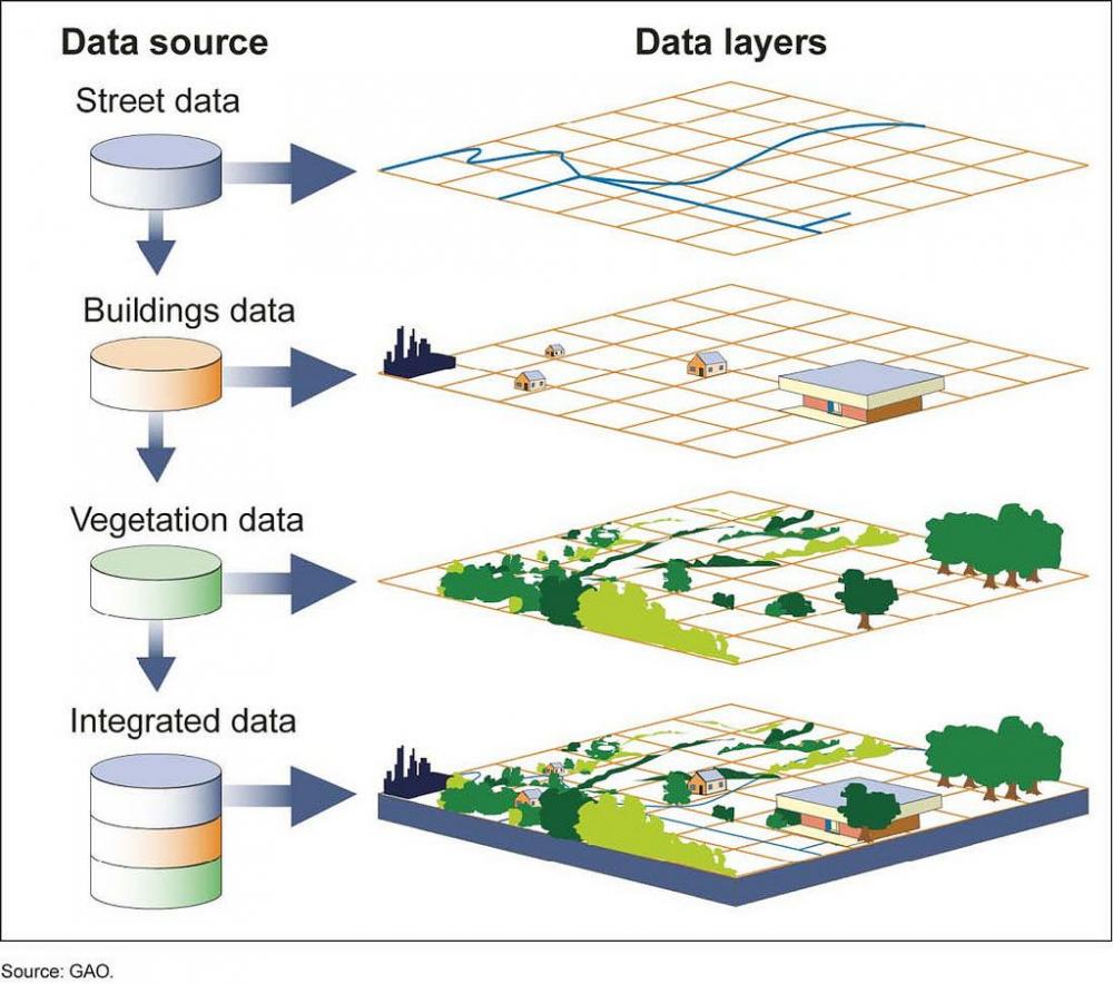
What is GIS?
A geographic information system (GIS) is a computer system for capturing, storing, checking, and displaying data related to positions on Earth’s surface. GIS can show many different kinds of data on one map, such as streets, buildings, and vegetation. This enables people to more easily see, analyze, and understand patterns and relationships.
Why GIS?
GIS connects spatial and non-spatial data together to help better inform our land use process.
Click any thumbnail image to view a slideshow